Kings Landing
March 3
Sunday
 Pre-registration is required and will open Monday February 26 and close at noon on Saturday, March 2.
There will be no day-of registration.
King's Landing is a small park, but thanks to the mapping efforts of Pam and Mike Dvorsky, an additional 960 adjacent acres of the Huntingtown Natural Resource Management Area (NRMA) is available for our use. This will be our second full event in this new area.
We’re still exploring how to optimize the event for our participants – this year, we’ll be shuttling most Advanced Participants to a Remote Start. See the course notes for details.
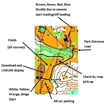
When you arrive, watch for guidance to the parking area from our volunteers and signs because the road to parking is narrow.
Brown through Blue will check in at Pavilion # 2, and register with e-punch at the Equestrian Pavilion then walk to the shuttle pick up location. Map issue will be at the remote start.
White through Beige map pick up and check in will be in Pavilion # 2, and e-punch registration / download will be at the Equestrian Pavilion. All starts and finishes are nearby.
This event is also a great opportunity to maximize your Orienteering experience. Course setter Mike Dvorsky is offering two Advanced Beginner (Yellow) courses with no shared controls except Start and Finish. This allows more practice at the event by running a second course ($2/2nd course). Contact the Event Director if interested in this option.
 Check in will open about 9:45 AM and courses will open at 10:00 AM. As always, please be off the course no later than 3 pm and remember to download at our e-punch station even if you did not finish. We want to make sure of everyone’s safety and status.
New! For the littler ones at this event: come and try the free "string-O". What's a string-O, you ask? As their first step towards becoming an orienteer, kiddos follow a course marked with string in a small forested area to find their favorite animals (under parental supervision). Minimum effort for parents, maximum fun for kids!
Your Map = A Free Cookie! After your run, join other orienteers and volunteers at the Chesapeake Grille & Deli in Dunkirk MD, located here about 10mi north of the event. Bring your map to get a free cookie with any purchase, courtesy of Alexis, the CG&D manager.
Free Beginner Instruction will be offered, but please reach out to the Event Director if you have a large group, so we can plan accordingly. Also, make sure to check out our Your First Event and Orienteering Techniques For Beginners webpages. Beginners are also encouraged to watch relevant videos such as this one created by QOC's instructional guru David Onkst. If they don’t answer any remaining questions you have, just use our Contact Form and ask.
Any youth or large groups attending, although you will be pre-registering online, please contact the Event Director of your plans and numbers for his situational awareness.
Leashed pets are allowed at Kings Landing and the Huntingtown NRMA.
Reminders:
- QOC will continue to use pre-registration as the ONLY method of signing up for our meets. There will be NO Planned day-of, on-site registration. Refunds are paid only in the case of event cancellation.
- As mentioned above, beginner instruction has resumed to provide an overview of orienteering basics for newcomers to the sport or those who just want a refresher.
- There is no drinking water on the course. Participants are responsible for their own hydration. A very limited supply of bottled water for emergency use will be on hand with the Event Director; but it is vital to stay well hydrated. Please come prepared!
- There will be no snacks offered by QOC.
- For this event (as with most others this season) there will be eight 15-minute check-in windows followed by two 45-minute windows.
- Port-a-johns will be on site near Pavilion #2.
- Maryland Department of Natural Resources maintains a port-a-john at the shuttle drop off location.
- Registration for QOC's Training Weekend is open from now until March 9 - everyone welcome from complete beginner to wise veteran!
| Location | King's Landing, Main parking area, Huntingtown, MD (Classic) | ||||||||||||||||||||||||||||||||||||||||
| Registration |
Registration opens at 6pm on Monday Feb. 26 and closes at 12 noon on Saturday March 2 (the day before the event). Pre-registration is mandatory. Who's Registered? Check by clicking here. | ||||||||||||||||||||||||||||||||||||||||
| Start Times | For this event (as with most others this season) there will be eight 15-minute check-in windows followed by two 45 min windows. | ||||||||||||||||||||||||||||||||||||||||
| Schedule | Sunday, March 3
| ||||||||||||||||||||||||||||||||||||||||
| Volunteers |
| ||||||||||||||||||||||||||||||||||||||||
| Location Details |
| ||||||||||||||||||||||||||||||||||||||||
| Course Details | Classic
| ||||||||||||||||||||||||||||||||||||||||
| Course Notes | Classic Contour Intervals are 5 meters (16.7 feet); the map was updated in 2023 and is accurate. LIVELOX will be used for this event on all courses. See the instructions on how to use this live GPS tracking by clicking here. It is especially recommended for use for runners on Brown, Green, Red and Blue courses in the NRMA as there is very limited vehicle access in that park and most areas are very remote. Click this link to register. (Yes, RouteGadget will also be available.) Note on moving up a course: The White, Yellow short, Yellow Long, Orange and Beige courses are normal level of difficulty and it would be fine to move up to a harder course. But this is probably NOT a good event to try Brown or above for the first time. The advanced course legs within the NRMA will demand careful route choices and strong map reading skills, dealing with unmanaged park terrain, an almost total lack of trails, and may be a tad bit more physically challenging. Kings Landing (all courses): The original 260 acre Kings Landing Park map was merged with the newly mapped (2022) 960 acre Huntingtown Natural Resources Management Area (NRMA) which borders to the north to make 1220 acres of orienteering terrain. This is the second QOC event to be held utilizing the NRMA with many map refinements made over the last year. Only Brown and above courses will venture into the wilderness of the NRMA. Those running the Brown and above courses will enjoy a beautiful 15 minute shuttle bus ride to the remote start. White, Yellow Short, Yellow Long, Orange and Beige courses will start near the registration area. The finish for all courses will be the same and will be near the registration. There WILL NOT be a clothing drop off at the remote start, so only bring what you plan on carrying on the course to the remote start. There is one paved road that bisects the Kings Landing Park. It is the entrance road and expect cars on this road. Runners should use caution crossing this road. The woods and fields are open and very runnable and visibility is excellent in both the park and NRMA. Don’t let the easy runnability lull you into a false sense of security. This park has some of the steepest terrain in QOC’s inventory. It looks benign on the drive in, but what you don’t see will give you burning thighs. Parallel errors have been known to happen in this park. The terrain is classic ridge and valley, with broad, flat ridges, lots of deeply incised spurs and reentrants and large marshes. The slopes are steep and can be as many as four to five contours high. These steep slopes may be slippery if it is or has been raining or snowing. Spiked shoes and gaiters are recommended. Some aggressive orienteers may decide to take a shortcut through a marshy area to save a few minutes. Sometimes the gamble will pay off, and sometimes it will backfire. Your choice! Be advised that if an area is mapped as uncrossable marsh (bold solid blue lines), you should consider it uncrossable (because it is!). Dashed blue lines or light solid blue mapped marsh may (or may not) be crossable. You should proceed at your own risk, but it may provide the fastest and shortest route to the next control. Your choice! Marshy areas and reentrants may be bone-dry or boot-sucking mud depending on the amount of rain we get during the week prior to the meet. Please make sure to tighten your orienteering shoes or you might lose them in the mud if you opt for that route. While Kings Landing Park is well-maintained with many manicured areas, the NRMA is just the opposite. With the exception of several cultivated fields which are leased to local farmers, the entire NRMA is an unmanaged, unimproved natural area in the process of being reclaimed by mother nature, with traces of civilization dating back to both colonial times and farming in the 1930’s-1960’s. Unique items to the NRMA for Brown, Green, Red and Blue course runners only: All advanced courses (Brown and above) will cross the Cocktown Creek while transiting from the remote start in the NRMA to the Finish in Kings Landing Park. There are no bridges or easy fording points across the creek. Depending on how much precipitation we get, the creek can range from a couple of inches deep to a couple of feet deep. Nominal width of the creek is 4-8 feet. Plan on getting your feet wet when you cross this creek. There is no way around the creek so find a crossing point you feel comfortable with, get your feet wet and carry on. The mapped light green tends to be areas with saplings and closely spaced trees. There is minimal clingy/grabby vegetation except in cleared areas near the road. But dead fall can always be an issue in unmanaged areas like this. Most major areas of deadfall are mapped with vertical green lines, unless they are inside an already marked green area where marking them would just add to confusion. Individual minor deadfall is generally not mapped unless it blocks a narrow route. The darker green tends to be areas of mountain laurel (a woody, stiff evergreen bush) that you can generally get through, though it will be at a slow walk/crouch and you may have to zig and zag around the stiff branches. Visibility is excellent throughout the park except in the mountain laurel thickets, which dominate in the central area of the NRMA. They are dense, slow to transverse, and can be disorienting. The vegetation boundaries should be used judiciously and with caution when navigating in the mountain laurel! The rides in the NRMA are in the process of being reclaimed by mother nature. At least one of the mapped rides dates back to colonial Maryland. Some less discernable rides have been mapped as less distinct trails where appropriate. Some parts of the rides may appear more like wide, shallow erosion gullies but if you use your imagination, you can almost visualize the horse and wagon traffic transporting tobacco to market. Don’t expect to use the rides as a clear, quick running path as most are blocked intermittently with deadfall. One ride was cleared by hunters this winter so it may prove to be more runnable. All advanced courses will cross the one limited access paved road in the NRMA. It is virtually never used except by the rare park ranger visit or farmer. I expect no traffic on this limited access road and you should be fine to cross it or use it as your route choice dictates. Within the NRMA, there is a large amount of broken ground, particularly along the sides of what once were roads. Only prominent knolls (4ft or higher) are mapped in these areas. In areas away from the broken ground, smaller knolls may be mapped. Otherwise the map would look like it had measles. This map of the NRMA is a work in progress (and can only be field checked during the non-hunting season!) so any comments on improving the map are welcome. | ||||||||||||||||||||||||||||||||||||||||
| Entry Fees | Individual Entries
Note: juniors = under 21
Group Entries Participants are welcome to orienteer together as a group (up to the maximum for that event; usually 4). Each member of a group is charged their individual rate as shown above, up to a group total of $30 (maximum), and each receives a map. A group receives one epunch. Individuals or groups desiring to compete on a second course after completing their first can do so for a reduced fee of $2/map subject to approval at the event by the Event Director. Important Notes
|