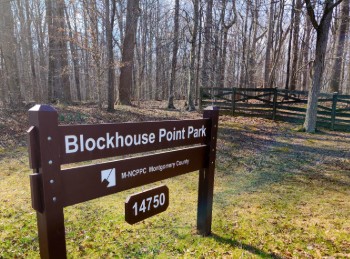
Blockhouse Point
April 13
Sunday
Orienteering at Blockhouse Point Park
Join Us for an Exciting Family Adventure!
Calling all adventure enthusiasts! We are thrilled to announce our first ever orienteering event at the beautiful Blockhouse Point Park in Potomac, Maryland. Whether you're a seasoned orienteer or a curious beginner, this event promises to be a fun and challenging experience for all. Come enjoy the rolling hills and fantastically open woods at this special venue.
What to Expect
Participants will navigate through diverse terrains, including wooded areas, open fields, and waterways, using a map and compass. This event is designed to test your navigation skills, endurance, and for groups, teamwork. Various courses will be available to accommodate all skill levels:- Beginner Course: Perfect for newcomers, offering a gentle introduction to orienteering with straightforward checkpoints and kid-friendly terrain. Beginner Instruction will be available.
- Intermediate Course: A bit more challenging, great for those with some orienteering experience looking to improve their skills.
- Advanced Courses: For experienced orienteers seeking a rigorous and demanding course with complex navigation.
What to Bring
Participants should come prepared with the following items:- Comfortable outdoor clothing and sturdy footwear
- Water bottle and snacks
- Compass and whistle if you have them. Loaners are available if needed.
Parking Details
Parking is limited at Blockhouse Point, so we have arranged for participants to park at the nearby Bretton Woods Country Club Swimming Pool parking lot 1.5 miles up River Road from the park. Shuttles will carry you to the check-in area at the park (where porta-johns will also be located). The ride takes about 4 minutes. Parking at the venue is restricted to event volunteers.
Groups
QOC allows groups of up to 4 people to orienteer together. Any youth or large groups attending this event should contact the Event Director in advance so that we can coordinate pre-registration for your group. Details and the required waiver form can be found on our For Group Leaders webpage.
Volunteer
![]() Volunteer: Sign up for a volunteer slot via this form, or email the Event Director directly for other options.
Volunteer: Sign up for a volunteer slot via this form, or email the Event Director directly for other options.
Post–event Social
After your run, join fellow orienteers at Brews and Barrels, located here just 7 miles from the park.Don't miss out on this opportunity to explore the natural beauty of Blockhouse Point and challenge yourself in a thrilling orienteering adventure. We look forward to seeing you there!
Happy orienteering!
| Location | Blockhouse Point, Bretton Woods Pool Parking, Darnestown, MD (Classic) | ||||||||||||||||||||||||||||||||||||
| Registration | Advance registration is required. Registration will open 6pm on Monday April 7 and close on Saturday April 12 at noon (the day before the event).
Who's Registered? Check by clicking here. | ||||||||||||||||||||||||||||||||||||
| Start Times | Start times will be by windows (to be defined for this event before registration opens). | ||||||||||||||||||||||||||||||||||||
| Schedule | Sunday, April 13
| ||||||||||||||||||||||||||||||||||||
| Volunteers |
| ||||||||||||||||||||||||||||||||||||
| Location Details |
| ||||||||||||||||||||||||||||||||||||
| Course Details | Classic
| ||||||||||||||||||||||||||||||||||||
| Course Notes | Classic This park, named after Civil War era fortifications on a big hill facing the Potomac River, has been used informally for orienteering training since at least 2007, but this will be QOC's inaugural public event. The courses have been kept away from the big cliffs but those on the Blue, Red, and Orange courses get close enough to consider taking a scenic detour on an official trail to either of two designated overlooks. From the overlooks, when the water level is low enough you’ll see lot’s of tiny rock islands stretching out towards Virginia (see photo below). The map was updated over the fall of 2024 and the winter of 2025. Like both the MD and VA Great Falls parks, it has wonderful grand views and has many quiet corners. Mature trees are found throughout most of the park and they create some very open forests that are suitable for fast running. There’s a horse farm on the edge of what’s mapped. Riders venture with their horses in Blockhouse, so if you see them, please stop and give right-of-way. After being dropped-off by the shuttle bus, White, Yellow, Orange, and Beige course orienteers will start and finish in the pipeline ride just beyond the gravel parking lot, on the parking lot (south) side of River Rd. Brown, Green, Red and Orange course runners will start on the Muddy Branch Trail, on the other (north) side of the road, just to the east of the pipeline ride. All advanced course orienteers will later cross back at a designated crossing point. This crossing will be off-the-clock (3 minute time limit) and will allow racers to safely get to the south side of River Rd. They will finish their course at the same place where the White, Yellow, Orange, and Beige course orienteers will, in the pipeline ride. Upon finishing, all will take the bus back to the designated parking area. Though there is a bit of a shoulder to River Rd., and the traffic is usually not very busy, please cross carefully. Cars using the road often speed. The courses are designed to keep off of the road. Overall, navigating in Blockhouse Point is not difficult. There is good visibility, there are plenty of trails, ridges, and other linear features to guide you when moving around. The hills in the park can be steep — they are often steepest at the bottom and round or rolling on top. Blue, Red and Orange courses encounter the largest hills late in their courses. The hills, cliffs, watercourses, fences and vegetation force many route choice considerations. Where there is green vegetation shown on the map, it’s usually light green and it’s for mountain laurel or for distinct groups of saplings. Mountain laurel clusters are also be mapped with medium greens but most medium green and fight areas are in the low flat lands near the C&O Canal. Places near the canal are the most thorny and bushy in the park. The use of Slow Run Low Vegetation (IOF symbol 407.000) on the map tends to be older deadfall. There is a small corner of the map that the Blue course will pass through where it’s not so old. The use of the denser Slow Run Walk Vegetation (IOF symbol 409.000) symbol on the map tends to be thorny vines and bushes but it’s occasionally applied to dense deadfall too. Because the trees in the park are usually mature, when they fall the rootstocks tend to raise-up lots of dirt, and sometimes stones. Many of these piles are over a meter tall. Unless the roots are visible and above the minimum 5 foot height threshold that was used for rootstock mapping, these occurrences have been mapped as dot knolls. Eventually, these dot knoll-rootstocks will compost and leave behind just distinct piles of dirt. There are a couple groups of man-made pits paired with dot knolls next to them. ISOM 2017 map symbols are too large for the distances between them to be shown accurately - they would overlap and become illegible. Exaggerated spacing has been used to keep the symbols apart. The true locations of these occurrences are centered on the dot knoll since the dot knolls are more visible than the pits. On the north side of the map, the Blue, Red, and Green courses have a route option through a narrow area between private property and the main creek. It is passable both above and below the cliff when water levels are normal. The Brown and Green courses have a similar route option situation, with a narrow passage between a cliff and a curving part of the main creek. That passage is not advantageous for the Brown course and could be difficult to use for both Brown and Green course orienteers who take the option because there is a treefall at a crucial point. There are some marshes in the floodplains. Some marshes are mapped as intermittent, but others are mapped in solid light blue to denote seasonal wetness (IOF Symbol 302.001), since they tend to be filled with water in the colder months. Sometimes linear (narrow) marshes (IOF Symbol 309.000) on the floodplains connect the other marshes with hardly any discernable depression. For this map, ditches on sloping ground that are not of sufficient depth to meet IOF standards have been shown as linear marshes to distinguish them from other deeper ditches — these are linear marshes that are often dry. Green, Red and Blue course orienteers will need to cross Muddy Branch Creek. Brown course orienteers may choose to cross Muddy Branch as a route choice. The creek is crossable in many places but there are many steep and tall creek banks; some of these banks are mapped as earth banks and are difficult to cross. In other places near or away from the creek, earth banks that are dangerous have been mapped as uncrossable cliffs (consistent with ISOM 2017). Storms can raise the Muddy Branch water level so, if water is too high, at the discretion of the meet director controls on a course that require crossing the creek may be dropped. Never cross if the water looks too fast or too deep. Course map scales will be 1:5000 for white, yellow & beige; 1:7500 for orange & brown; and 1:10000 for green, red & blue.
| ||||||||||||||||||||||||||||||||||||
| Entry Fees | Individual Entries
Note: juniors = under 21
Group Entries Participants are welcome to orienteer together as a group (up to the maximum for that event; usually 4). Each member of a group is charged their individual rate as shown above, up to a group total of $30 (maximum), and each receives a map. A group receives one epunch. Individuals or groups desiring to compete on a second course after completing their first can do so for a reduced fee of $2/map subject to approval at the event by the Event Director. Important Notes
|
