Pohick Bay Regional Park
| Location | Directions |
|---|---|
| Pavilion 3 Google Map | From southbound I-95, take exit 163 (Lorton). Go left onto Lorton Rd at the end of exit ramp. Go under the 2nd overpass and turn right onto Lorton Market St (Z-pizza is in the shopping center on the left), then go about 1.5 miles to the traffic light at Route 1. Go straight through light (the road name changes to Gunston Rd) and go about 4 miles to the park entrance on left. After passing through the gate, continue down the main park road to the end and park in the LARGE lots to the west (by the boat launches). Walk about ~125 meters to Shelter 3, which is on the east side of the main entrance road (look for the QOC banner). Please note that a park entry fee must be paid to the attendant at the park gate. Those who live in the NOVA Parks jurisdiction (residents of Arlington, Fairfax and Loudoun Counties; Cities of Alexandria, Fairfax & Falls Church) are admitted free; please be prepared to show ID at gate. Those who live outside the jurisdiction will pay $4 per vehicle at the gate (the shelter-rental rate). PLEASE inform the attendant that they are there for the orienteering event at SHELTER 3. |
| Camp Wilson Google Map | From I-95 exit 163 (Lorton Rd, VA-642), head east, then turn right/south on Rt 1 (Richmond Hwy). Turn left on Rt 600/242 (Gunston Rd), and then drive 1.5 miles until and turn left on a dirt road marked by a Camp Wilson sign, immediately before the Gunston Fire Station. If you see the main entrance to Pohick Bay Park you've gone too far. Google Maps Link Apple/iPhone Link |
| Eagle's Nest Google Map | From southbound I-95, take exit 163 (Lorton). Go left onto Lorton Rd at the end of exit ramp. Go under the 2nd overpass and turn right onto Lorton Market St (Z-pizza is in the shopping center on the left), then go about 1.5 miles to the traffic light at Route 1. Go straight through light (the road name changes to Gunston Rd) and go about 4 miles to the park entrance on left. Let the entrance staff know you are part of the orienteering event so you don't pay admission. Park in the large lot on the right just beyond the mini-golf course and near Pavilions 1 and 2. Then find the trail head that is clearly identified at the northeastern corner of the parking lot, and walk down it to the shoreline and to the Eagle's Nest pavilion where registration will be. Traffic on the road may be heavy so please use the trail as indicated. |
| Shelter 1 Google Map | From southbound I-95, take exit 163 (Lorton). Go left onto Lorton Rd at the end of exit ramp. Go under the 2nd overpass and turn right onto Lorton Market St (Z-pizza is in the shopping center on the left), then go about 1.5 miles to the traffic light at Route 1. Go straight through light (the road name changes to Gunston Rd) and go about 4 miles to the park entrance on left. After passing through the gate, straight on the main park road until just past the disc golf course and into the large parking lot on your right. Shelter 1 is SE of the parking lot and is the southern most of the two shelters. Google Maps Link Apple/iPhone Link |
| Shelter 2 Google Map | From southbound I-95, take exit 163 (Lorton). Go left onto Lorton Rd at the end of exit ramp. Go under the 2nd overpass and turn right onto Lorton Market St (Z-pizza is in the shopping center on the left), then go about 1.5 miles to the traffic light at Route 1. Go straight through light (the road name changes to Gunston Rd) and go about 4 miles to the park entrance on left. After passing through the gate, straight on the main park road until just past the disc golf course and into the large parking lot on your right. Shelter 2 is east of the parking lot and is the northern most of the two shelters. |
Upcoming Events at this Venue
There are currently no events scheduled at this venue in the next six months. Please check back later or consider hosting an event at this venue with full club support.
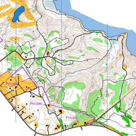
Sample Orienteering Map